


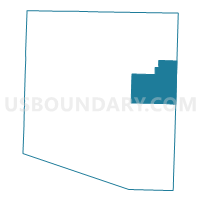
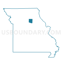
Union Voting District, Randolph County, Missouri
About
Outline

Summary
| Unique Area Identifier | 609514 |
| Name | Union Voting District |
| County | Randolph County |
| State | Missouri |
| Area (square miles) | 30.61 |
| Land Area (square miles) | 30.61 |
| Water Area (square miles) | 0.00 |
| % of Land Area | 100.00 |
| % of Water Area | 0.00 |
| Latitude of the Internal Point | 39.45437050 |
| Longtitude of the Internal Point | -92.34738710 |
Maps

Graphs
Select a template below for downloading or customizing gragh for Union Voting District, Randolph County, Missouri


Neighbors
Neighoring Voting District (by Name) Neighboring Voting District on the Map
- Cairo Voting District, Randolph County, MO
- Duncans Bridge 7 & 8/Madison 10 & 11 Voting District, Monroe County, MO
- Levicks Mill Voting District, Randolph County, MO
- North Sugar Creek Voting District, Randolph County, MO
- South Sugar Creek Voting District, Randolph County, MO
- Union 12 & 13 Voting District, Monroe County, MO
Top 10 Neighboring County Subdivision (by Population) Neighboring County Subdivision on the Map
- South Sugar Creek township, Randolph County, MO (7,499)
- North Sugar Creek township, Randolph County, MO (5,994)
- Marion township, Monroe County, MO (1,363)
- Cairo township, Randolph County, MO (1,257)
- Union township, Randolph County, MO (957)
- Union township, Monroe County, MO (850)
- Salt River township, Randolph County, MO (383)
Top 10 Neighboring Place (by Population) Neighboring Place on the Map
Top 10 Neighboring Elementary School District (by Population) Neighboring Elementary School District on the Map
Top 10 Neighboring Unified School District (by Population) Neighboring Unified School District on the Map
- Moberly School District, MO (16,390)
- Northeast Randolph County R-IV School District, MO (2,015)
- Madison C-3 School District, MO (1,419)
Top 10 Neighboring State Legislative District Lower Chamber (by Population) Neighboring State Legislative District Lower Chamber on the Map
Top 10 Neighboring State Legislative District Upper Chamber (by Population) Neighboring State Legislative District Upper Chamber on the Map
Top 10 Neighboring 111th Congressional District (by Population) Neighboring 111th Congressional District on the Map
Top 10 Neighboring Census Tract (by Population) Neighboring Census Tract on the Map
- Census Tract 4903, Randolph County, MO (4,774)
- Census Tract 4901, Randolph County, MO (3,783)
- Census Tract 9603, Monroe County, MO (2,745)